GO - FÓSFORO
Projects / Scientific Research

Operational Group GO Fósforo - Increasing the viability of sown biodiverse pastures through optimization of phosphate fertilization.
Most Portuguese pastures are poor grasslands on degraded soils. Some farmers invest in improved and fertilized grasslands, namely sown biodiverse pastures, however their economic viability is threatened by production costs, namely phosphate fertilizers.
Project objectives
- Implement tech-based low-cost methods for evaluating real phosphorus needs by using remote data sensing
- Optimize the use of fertilizers in sown biodiverse pastures using Variable Rate Technology for fertilizer distribution
- Demonstrate positive impacts on yield and environmental benefits
- Disseminate results to farmers and consultants and provide fine-tuned recommendations for efficient phosphorus fertilization
General Information
Technical Information
Type of project
- Operational Groups
Project number
- PDR2020-101-030690
Partners name
- Terraprima – Serviços Ambientais, Sociedade Unipessoal Lda. (leader)
- Universidade de Évora
- Associação dos Criadores de Bovinos da Raça Alentejana
- Herdade dos Grous – Agricultura e Pecuária, Lda.
- Terraprima Sociedade Agrícola Lda.
- Fundação Eugénio de Almeida
- Sociedade Agricola Herdade dos Padres, SA
- ZEA - Sociedade Agrícola Unipessoal, Lda
- Tapada dos Números, Sociedade Agricola, Lda
- Instituto Superior de Agronomia
- Pedro Sacadura Teixeira Cabral Duarte da Silveira - Herdade do Azinhal
Who will benefit
- Farmers will benefit from optimizing pasture fertilization, improving its productivity and decreasing production costs.
Start date
- 01/05/2017
End date
- 31/12/2022
Total eligible cost
- 503 033.46 €
Name and contact
- Nuno Rodrigues (nuno.rodrigues@terraprima.pt)
Results so far/First lessons
- The preparation of the project led to the establishment of a network of farmers and research entities, which will enable the project to address and compare different setups (in terms of farm practices, pasture and soil characteristics and weather variability). Farmers are taking part of the project since the beginning and have a crucial role in all project activities.
Expected Results
- Technological method for obtaining high-resolution phosphate fertilization prescription maps.
- Obtain phosphate fertilization prescriptions in order to optimize pasture productivity and to reduce production costs.
- Establish a service to farmers in improving the economic viability of sown biodiverse pasture.
Main Conclusions and Future Work
This Operational Group (OG) set out to introduce more innovation into the management of biodiverse sown pastures by introducing Industry 4.0 tools, specifically with regard to promoting adequate and rational phosphate fertilisation of pastures, with the aim of boosting the sustainability of the system and the resulting economic, social and environmental benefits of this agricultural activity.
Fertilisation using phosphate fertiliser is one of the determining and limiting factors for the correct maintenance and good productivity of biodiverse sown pastures. On the other hand, this mineral fertiliser, based on phosphate rock, comes from a non-renewable and limited natural resource.
Fertilisation that is not balanced (either by deficit or excess) in terms of phosphorus, and that disregards the local biophysical characteristics (orography, nutrients in the soil, floristic composition, climate, etc.), can lead to failure and lower pasture productivity.
On the other hand, the inefficient utilisation of the phosphorus nutrient by plants implies not only a direct economic impact on the farmer but also an environmental impact, both through phosphorus leaching processes and the waste of a limited natural resource.
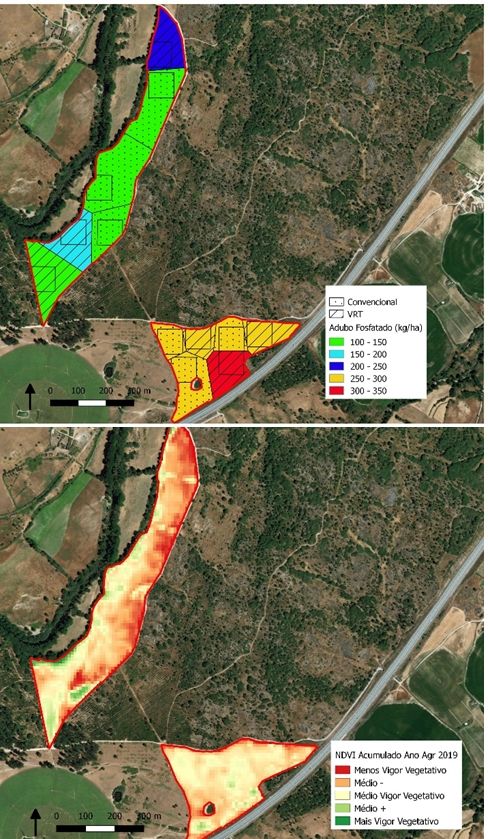
The correct application of this important production factor is therefore highly dependent on knowledge of the conditions of both the pasture and the soil and, above all, the nutritional characteristics of both, which show different spatial variability. It is therefore important for the farmer to know this spatial variability in order to make informed decisions about the quantities and places to apply phosphate fertiliser. Combining knowledge of the system with concern for environmental and economic impacts allows the farmer to make a planned and informed management of the fertilisation process.
The inclusion of technology in the area of agricultural production is already a reality on many farms, with the use of Geographic Information Systems (GIS) being one of the most impactful components, namely through the mapping of land occupations and operations, with the geolocalisation of operations in real time, using GPS technology, being the most relevant.
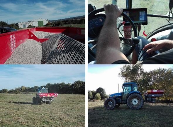
Agricultural equipment technology is increasingly using GPS geolocation systems, either directly to support real-time navigation or to carry out operations that are predefined according to spatially distinct maps and criteria. In this sense, and within the scope of this OG, specifically in the area of rational pasture fertilisation with phosphorus, a technology was tested using equipment that allows spatially differentiated fertilisation (VRT) according to fertilisation maps, i.e. the application of the estimated amount of fertiliser in the predefined location.
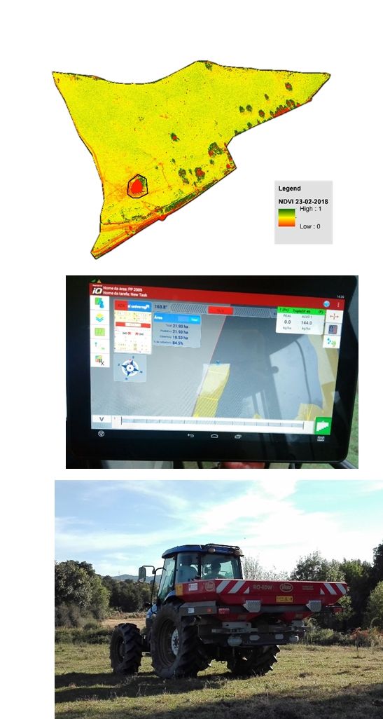
One of the most disruptive GIS technological components in the area of spatial analysis, and one that necessarily serves agricultural management, is the availability of high-resolution remote sensing information with spatial coverage, free of charge and publicly accessible, in particular the satellite images provided by the European Copernicos system of the Sentinel2 pair of earth observation satellites.
The use of drones (VANTS) is currently a very useful tool for collecting spatial information based on close detection, which can be linked with remote information from satellites on the one hand and, on the other, with data from local sensors collecting information on the ground.
Event modelling technology using Artificial Intelligence (AI) algorithms and the greater computing power available have added exponentially more powerful tools for analysing data across a broad spectrum and in quantity ("Big Data" - local, near and remote data), in order to contribute to the production and estimation of spatial information useful for agricultural decision making and management.
With this in mind, and in line with the above, this project focused on investigating local data (pasture analysis, soil analysis, terrain analysis), near data (drone flights) and remote data (satellite images) in a combined way, in order to produce innovation in pasture management with regard to phosphate fertilisation.
The main conclusions reached by this OG are, firstly, the importance of spatially differentiated knowledge of pasture, terrain and soil characteristics. This knowledge about pastures and soil can be modulated using AI-based computing, first trained with local and nearby data and then estimated using freely available, regular and globally covered remote spatial data. This work resulted in models for estimating maps of biomass (ton/ha), legume content (%) and soil organic matter (%), based on Sentinel2 images, for biodiverse sown pastures.
The second main conclusion of the OG is the feasibility of applying fertiliser using a spatially differentiated technique from VRT technology. It was possible to test and confirm the correct application of a previously defined prescription from a pasture management perspective, in the desired quantity and in the indicated locations, i.e. that the equipment applies fertiliser in line with a fertiliser prescription map, which takes into account the needs of the plants, the nutrients available in the soil and the technical recommendations for phosphorus fertilisation in pastures, converted into a prescription map. This process was easy for the operator to implement and carry out, and it can also be concluded that VRT technology is a valuable process for supporting fertilisation operations and managing the production factor of phosphate fertiliser, with direct economic and environmental impacts.
As prospects for future work following on from this OG, we recognise two important points that could certainly improve the results and conclusions described above.
The first relates to the need to calibrate the AI model based on data collected in other spatial and temporal realities, i.e. AI models are more robust the more and more diverse the information used to train the model, preferably covering different biophysical realities and phenological states of plants, namely at different times of the year and in different years, as well as at different latitudes in the territory. Calibrating the model with more data will also make it possible to use satellite images on dates without cloud cover to estimate and model the results for dates and periods with greater cloud cover.
The second point of perspective for future work is related to the study of the limiting factors in the absorption of phosphorus by plants, namely taking into account the needs and availability of phosphorus (and other chemical and physical characteristics) in the soil for plants, and how this relates to productivity.
Explore and discover